Mon,Sep 30,2013
 |
| (Provided to People's Daily Online/Guo Hairan) |
Recommended Destinations for Adventures 2:
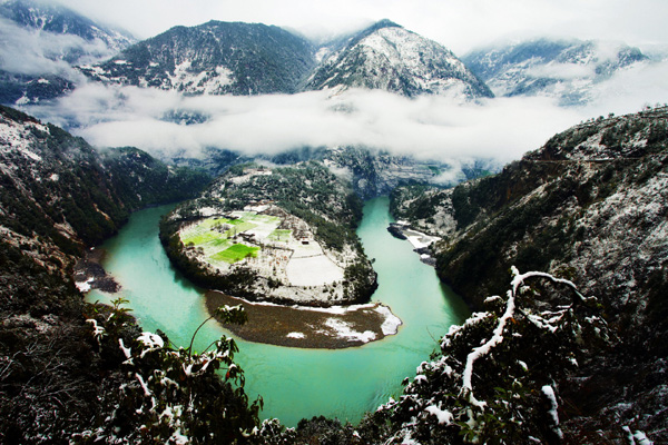
Nujiang is one of the rivers within the Three Rivers Natural Reserve, a world heritage site listed by UNESCO. Nujiang is located throughout southwest China's Yunnan Province and flows into Myanmar, where it joins the Salween River and ends its journey at the India Ocean.
As affected by the southwestern monsoon climate of the Indian Ocean, the Grand Gorge of the Nujiang River forms a special climate that there are four seasons in a same mountain and the weathers are different within five kilometers. It is a common phenomenon that the trees are verdant and green in the river valley that is sweltering as in summer, the flowers are in full bloom, the grasses become yellow on the sidehill, and the mountaintop is the world of ice and snow as in winter.
Biluo Mountain is situated at the east of the Nujiang River and Gaoligong Mountain is standing at its west, with snow peaks around the Grand Gorge. Due to the landform and altitude, it is colder in its northern part and warmer in the south.
The scenery between Fugong and Gongshan is awe-inspiring with many cliffs, clear green river-water and waterfalls. The first hairpin bend came into sight near Bingzhongluo.
Lying in the longitudinal valley area of Hengduan Mountains in western Yunnan, Nujiang is made up of lofty mountains and roaring rivers, with more than forty peaks in the prefecture over 4,000 (13,123) meters high. Its terrain generally slopes downward from north to south. Other than a small area of flat land on the fringe, Lancang and Dulong rivers, mountainous regions constitute the main part of the area.
The Nujiang River surges forward between Gaoligong Mountain and Biluo Mountain. The altitudes of all the mountains beside the two banks are over 3,000 meters. As the drop height of the river is high, the river water is rapidly rushing and the wave is high, forming a very spectacular sight. There are many steep cliffs at both banks. Flowing toward the south with an annual water amount of 1.6 times that of the Yellow River, the river is impinging against the banks and thus forms the steepy Grand Gorge of the Orient with high mountains and deep valley.
 National Plug In Day celebrated in Washington D.C.
 New model of indigenous surface-to-air missiles testfired
  118.28-carat diamond to be auctioned in HK
 Maternal love under streetlight
 Naked foreign student sits in the middle of a road in Haikou
  Colorful Yunnan: Enjoy the natural beauty
 Harbin named Chinese city with most beautiful women
 For last four students, teacher couple sticks to post on island
  When big sport stars were kids
 PLA's 38th Group Army conduct training
 People mourn for victims of mall attack
 The last days of Wan Aihua
 Highlights at 12th National Games of China
 Beijing Film Academy welcomes freshmen
 Large mahjong party sets new world record
Day|Week|Month